Address:
2150 Nolin Dam Road
Mammoth Cave, KY 42259
Phone: (270) 286-4511
Office Hours: M-Th, 6:30 a.m. - 4 p.m. and Friday 6:30 - 3 p.m. (Central Time) (may vary, please call ahead)
Lake Levels
Lake Temperatures
Please visit our Facebook page by clicking here.
Location
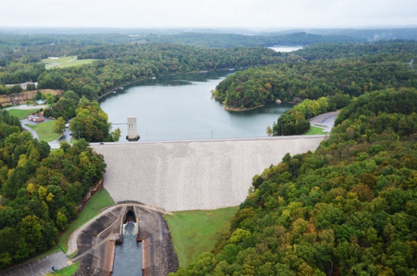
Nolin River Dam is located about 8 miles above the Confluence of the Nolin and Green Rivers near the community of Bee Spring. While the dam is located in Edmonson County, the lake also covers portions of Grayson and Hart Counties. The dam is about 8 miles north of Brownsville, 20 miles from Leitchfield, and 95 miles southwest of Louisville.
Authorization
The dam was constructed to control flooding on the Nolin and Green Rivers, as part of an overall "Comprehensive Flood Control Plan for the Ohio and Mississippi Rivers". In 1931, a thorough survey of the area was completed and 7 possible locations for the dam were identified. The one selected offered the most control of flood waters and was the only one which appeared to offer any possibility of commercially feasible power development. However, the 1931 conclusion was that construction of this flood control reservoir was not justified at the time. Following the Ohio River flooding in 1937, construction of an additional 45 reservoirs was recommended, including the Nolin River Reservoir. Construction was authorized by the Flood Control Act of 1938. The U.S. Army Corps of Engineers designed, built, and operates the project to reduce flooding downstream from the dam.
Construction of the operating tower and outlet works began in January 1959 and was completed in July 1961. Construction of the dam and spillway was begun in June 1961 and completed in May 1963. The reservoir was placed in complete operation on March 4th, 1963 and minimum pool (480) was reached on March 7th (minimum/winter pool was 12' lower back then--it's 492' now.) Summer pool was not reached in 1963 due to insufficient runoff.
Total construction cost was $14.5 Million, but the dam has saved over $115 Million in flood damages through 2014. In addition, economic benefits from the lake are between $35 and $45 Million each year. Visitation averages about 2 million people each year.
In addition to flood control and recreational benefits, the lake also supplies drinking water to the surrounding area, as well as providing fish and wildlife habitat.
History
The Nolin River is named for the early American explorer and Kentucky militia member, Benjamin Lynn. Serving under George Rogers Clark during the Revolutionary War, Lynn traveled to Illinois to spy on the British and Indian forces, and also played a pivotal role in the Northwest Campaign on 1778-79. Following his return to Kentucky, Lynn and several friends were camped in the Green River Area. Lynn became separated from his friends and could not be found for several days. Each night, they returned from the search reporting “No Lynn.” The river at which they camped became known as the Nolin.
Many of the early settlers in the area around the Nolin River came from Nordic regions which is reflected in community names such as Stockholm and Sweeden. Others came from France, showing influence through community names like Moutardier and Chalybeate. Rich in culture, the local area mirrors history and tradition in small businesses around the lake.
Shoreline Use, Permits and Licenses
Nolin River Lake allows shoreline uses through permits and licenses in accordance with their lake’s Shoreline Management Plan. For questions about this, please contact the project office at (270) 286-4511.
Nolin Lake Historical Photos
Follow this link to our Nolin Historical Photo Album on Facebook: https://www.facebook.com/pg/Nolin.River.Lake/photos/?tab=album&album_id=190621854298094
2009 Ice Storm: https://www.facebook.com/media/set/?set=a.1039308992762705.1073741864.190419507651662&type=3&uploaded=17
2011 Flood: https://www.facebook.com/pg/Nolin.River.Lake/photos/?tab=album&album_id=654695727890702
2014 Ice Music Video: