The U.S. Army Corps of Engineers Louisville District is committed to providing clear communication and resources as you continue to deal with high water and seek to prepare for future events. We want to provide some clarity on USACE operations during high-water events and how those operations impact residents near Buckhorn Lake. Below are some Frequently Asked Questions (FAQs) and responses.
Q1: At what elevation does HWY KY257 near Buckhorn Lake become inundated?
KY257 as well as multiple county roads begin flooding at elevation 805’ MSL (mean sea level). As water levels continue to rise, additional sections of KY 257 and more county roads may become inundated. The U.S. Army Corps of Engineers is committed to notifying Leslie County officials when a high-water event is possible and could reach an elevation of 804 feet, allowing necessary preparations for potential road flooding. Additional inundation levels are listed below:
HWY 257 at Mile Branch becomes inundated at 832 feet MSL.
HWY 257 at Paw Paw Branch becomes inundated at 826 feet MSL.
HWY 257 at Bull Creek Road becomes inundated at 822 feet MSL.
HWY 257 ¼ mile below Peach Orchard Branch becomes inundated at 815 feet MSL.
Q2: How does USACE communicate to residents that Buckhorn Lake is expected to reach 805 MSL elevation and that HWY 257 will become inundated?
The U.S. Army Corps of Engineers is committed to keeping the community informed before high-water events at Buckhorn Lake. Per protocol, the U.S. Army Corps of Engineers notifies Leslie County officials when a high-water event is possible and may reach an elevation of 804 feet MSL, allowing necessary preparations for potential road flooding. Additionally, once the U.S. Army Corps of Engineers determines that the pool elevation will reach 805 feet, the Louisville District will issue a news release to local media outlets and provide updates on the Buckhorn Lake Facebook page at: https://www.facebook.com/BuckhornLakeUSACE/.
Q3: Does USACE have the right to flood HWY 257?
Yes, when the U.S. Army Corps of Engineers, Louisville District constructed Buckhorn Lake, the Commonwealth of Kentucky subordinated its right to operate Kentucky Highway No. 257 to the rights of the Corps to operate Buckhorn Lake through a Subordination Agreement. In the same manner, a Subordination Agreement was executed by Leslie County for county-owned roads within the project area located between elevations 757 and 845.
Q4: What if I believe there is a discrepancy in the property boundary?
The U.S. Army Corps of Engineers Louisville District purchased the right to flood properties via fee and flowage easement acquisitions with an upper guide elevation of 845 MSL around Buckhorn Lake. If you have questions or concerns regarding your boundary line, we encourage residents to reach out to the county courthouse to obtain Government title records and if necessary, hire a licensed surveyor to confirm your property boundary. If you have questions or concerns regarding the USACE fee line or flowage easements, please contact the Louisville District Public Affairs Office at lrl-pao@usace.army.mil and we will put you in contact with our Real Estate team for further discussions. The Corps can work with your surveyor to provide assistance as needed.
Q6: Can USACE build new transportation infrastructure, so residents have another route out if HWY 257 or county roads are inundated due to flooding?
Historically, modification of existing roadways falls upon the State and county transportation authorities. USACE can however, assist with feasibility studies, at the request of local or state government. Additionally, USACE, along with the Kentucky Division of Water, is currently leading a $3 million Flood Risk Management study to develop long-term, sustainable solutions for Eastern Kentucky communities historically impacted by severe flooding. USACE remains committed to helping Eastern Kentucky build a safer, more resilient future through data-driven, sustainable flood risk management strategies. In our ongoing study, we are exploring any and all available options that could reduce the risks of flooding and loss of life. We are actively engaging with residents, local leaders and stakeholders to ensure the best possible solutions for flood-prone areas. The public is encouraged to submit feedback as part of that study using the public involvement tool at: Public Comment Tool
Q7: The swinging bridge along HWY 257 has been washed away. What are the next steps for repair?
While the swinging bridge is located on U.S. Federal Government Property, it is owned, operated and maintained through a real estate license to the Leslie County Fiscal Court.
Q8: Is there an emergency evacuation service or ferry service available for residents, and if so, who do we contact to request ferry services?
Residents in the Dry Hill /Confluence areas that are affected, or anticipate they will be affected, by high-water on HWY257 or other county road closures are encouraged to coordinate with Leslie County Officials. For any inquiries regarding boat service, or to request non-emergency services, please contact the Leslie County non-emergency services line at: (606) 672-2986. For emergency situations, contact 911. These services are managed by the county, and not the U.S. Army Corps of Engineers.
Q9: Why does USACE not support or run a ferry service?
Subordination agreements between the U.S. Government and the state and local government gives the U.S. Army Corps of Engineers the right to flood the roads in the project area therefore placing responsibilities for other emergency preparedness and planning activities on the county and state. These emergency evacuation services/ferry services are managed by the county, and not the U.S. Army Corps of Engineers.
Q10: Can USACE provide free rooms at the Buckhorn Lodge or other lodging while residents are displaced during flooding while the roads are closed?
No. The Buckhorn State Park Lodge is owned and operated by the State of Kentucky. The U.S. Army Corps of Engineers Louisville District does not have any authorization or appropriation that allows for lodging of displaced residents. Residents who are displaced, or believe they may become displaced, due to ingress/egress issues due to flooding, should contact their local authorities for further assistance.
Q11: Where can I find historical data of highest lake elevations?
Historical reports noting pool of record elevations can be found on our website under the header “Reservoir Forecasts” at: https://www.lrd.usace.army.mil/Rivers-and-Reservoirs/.
Q12: Why can’t the Corps adjust the water release volumes dictated by the Water Control Manual? USACE makes day to day decisions about releasing water through its dams according to Water Control Manuals —or operating manuals for USACE dams. The objective of all WCMs include operating the dam and reservoir for the purposes authorized by Congress and other applicable law, maintaining the structural integrity and operation integrity of the dam and avoiding risk to public health and safety, life and property. Our Water Control Manual specifies the maximum amount of water we can release and not damage anything when downstream conditions are conducive to high releases. The process for updating a Water Control Manual would involve congressional approval, a feasibility study, public input and subsequent analysis, to conclude whether changes may be warranted. The Water Control Manual is reviewed periodically for effectiveness and the Buckhorn Lake WCM continues to meet the congressionally authorized purposes.
Q13: Was water released prior to the storm event to increase lake capacity in anticipation of heavy rainfall?
Yes, the U.S. Army Corps of Engineers Water Management team is constantly forecasting and making necessary adjustments prior to rainfall events. In this instance (February 2025 event), releases were limited due to already elevated river stages (downstream control points) downstream of the dam. We were following the procedures outlined in the Water Control Manual to meet the authorized purposes which include Flood Risk Mitigation for the Kentucky River and Ohio River, Recreation, and Water Quality. Additionally, the reservoir had 80% of flood storage capacity available in preparation for this event.
Q14: What caused the extensive flooding at Buckhorn Lake in February 2025?
Immediately after rainfall, flooding can occur far upstream as the river rapidly responds to the rainfall. As the lake starts to fill and impounds water, backwater effects/impacts begin to occur closer to the dam. In this specific event (February 2025) communities closer to the dam likely experienced impacts from backwater flooding Saturday afternoon into Saturday evening. Residents further upstream in Hyden would have seen significant flash flooding late Saturday night and then backwater impacts about a day and half later -- almost in two distinct events. The U.S. Army Corps of Engineers Louisville District purchased the right to flood properties via fee and flowage easement acquisitions with an upper guide elevation of 845 MSL around Buckhorn Lake.
Q15: Why does the dam hold back water when there is flooding?
The U.S. Army Corps of Engineers manages water releases based on our Water Control Manual. Buckhorn Dam is designed to minimize flood damages by storing water caused by heavy rains until the rivers and streams are at levels that releases from the reservoirs will not cause additional flooding downstream. We remain committed to working within the approved operating criteria to release water as fast as possible. The congressionally authorized purposes for Buckhorn are Flood Risk Mitigation for the Kentucky River and the Ohio River, Recreation, and Water Quality.
Q16: What is USACE doing to maintain flood storage capacity at Buckhorn? Does the lake get regularly dredged?
Sedimentation in Buckhorn Reservoir has a very small impact to the flood storage capacity. The U.S. Army Corps of Engineers Louisville District has taken initial steps to better understand the accumulation of sedimentation at Buckhorn Lake by performing a sediment survey for the purpose of re-evaluating reservoir storage. The lake does not get dredged because the impact of sedimentation on flood storage capacity is very small, and further analyses would still need to occur before any proposed actions could be developed/recommended. If these analyses suggested reservoir dredging would be beneficial, funding would need to be appropriated accordingly. Ultimately, dredging is not going to eliminate high-reservoir levels; rainfall frequency and intensity, as well as the operating criteria used to meet the congressionally authorized purposes are the primary contributors to reservoir levels.
Q17: Are flooding events happening more frequently at Buckhorn Lake in recent years due to increased rainfall?
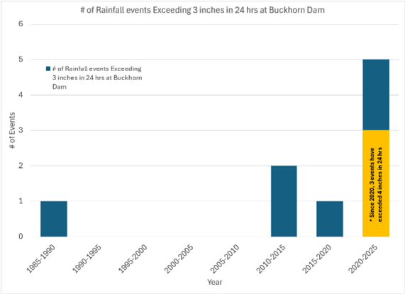
Runoff due to high intensity rain has become more frequent in the Buckhorn Reservoir watershed in recent years. From 1983 - 2012 there was only a single rain event where more than 3 inches fell in a 24-hr period. From 2013 - 2020 there were three events that exceeded 3 inches in 24 hrs. From 2021 - 2025 there were five events that exceeded 3 inches in 24 hrs, and three of those events exceeded 4 inches in 24 hrs.
Q18: Is there any funding/authorization for USACE to clear and dredge our streams/waterways in EKY?
The U.S. Army Corps of Engineers (USACE) has received several questions about the clearing of streams and waterways in Eastern Kentucky. Below is additional information on available programs and USACE’s role in authorizing dredging activities.
Section 208 of the Flood Control Act of 1954, as amended (33 U.S.C. § 701g), generally authorizes allocating appropriations for removing accumulated snags and other debris, and for clearing channels in navigable streams and their tributaries. The maximum Federal cost for the project development and construction under the Section 208 program for any single tributary is $1 million, and prior to implementation, a study must be done to determine if the project is economically justified and feasible. The program is cost shared on a 65% Federal/35% non-Federal basis. A request from a potential non-Federal Sponsor (state or local government) is required in order to request funding under Section 208. Funding for this program has been historically limited at a national level. At this time, the Louisville District has not received a request from a potential non-Federal sponsor for the Section 208 program in response to the 2021 or 2022 floods.
Considering these limitations, USACE also refers local and state governments and property owners to the Natural Resources Conservation Service (NRCS) Emergency Watershed Protection (EWP) Program as a potential alternative to a Section 208 project. This program helps with debris removal from streams, culverts, and bridges on a cost-shared basis and has historically received funding to include a relatively recent funding of $925 million through the Consolidated Appropriations Act, 2023 (Pub. L. 117-328; 136 Stat. 4459). If you are looking for help through the NRCS EWP program, we recommend working with your local government to contact NRCS.
Separately, USACE reviews and approves Department of Army (DA) permits for activities within waters of the United States under Section 404 of the Clean Water Act, which could include dredging or clearing activities. USACE remains committed to expediting permit evaluations to assist with post-flood recovery throughout the Commonwealth of Kentucky. USACE fully supports and encourages efforts to clear trees, logjams, and debris from streams—especially when debris could block a bridge or culvert and cause or exacerbate flooding. We have been actively working with communities in Eastern Kentucky to share information about expediting DA permits for flood-related projects. USACE is committed to assisting the public during emergencies, including helping expedite the DA permit review process for work within waters of the United States. Local and State governments and property owners should contact the appropriate USACE District to determine DA permit requirements or applicability of Section 404 Clean Water Act exemptions for your project. Many projects don’t require a DA permit, and for those that do, we process them quickly. If you need more info or want to speak with someone from our Regulatory Division, just let us know via e-mail at lrl-pao@usace.army.mil—we’re here to help!
Q20: Why does USACE no longer run a ferry service?
In 1986/1987, it was determined that the U.S. Army Corps of Engineers (USACE) does not have authorization to provide ferry services. While some residents may recall USACE assistance in the past, the last time USACE personnel assisted with ferry service was on May 19, 1984. In 1987, USACE loaned boats from the project to Leslie County, and in 2015, the Louisville District followed proper procedures to transfer excess government property and provided one boat to Leslie County for their use. In limited circumstances, such as life-threatening emergencies, USACE may obtain command authorization to provide emergency assistance once all other available resources are fully exhausted. The Buckhorn Lake Project Office is staffed strictly for authorized project missions, not emergency services. The Leslie County Emergency Operations Center (EOC) is best suited for emergency response, as local officials are more familiar with the area's roads, communities, and specific needs. These emergency evacuation services/ferry services are managed by the county, and not the U.S. Army Corps of Engineers. Residents in the Dry Hill /Confluence areas that are affected, or anticipate they will be affected, by high-water on HWY257 or other county road closures are encouraged to coordinate with Leslie County Officials. For any inquiries regarding boat service, or to request non-emergency services, please contact the Leslie County non-emergency services line at: (606) 672-2986. For emergency situations, contact 911.
Q21: Why has the lake not reached winter pool yet? (as of 14 MAR)
Buckhorn Dam operations have been targeting winter pool since December, but frequent rain events have caused the lake to remain above winter pool. We have been releasing water as aggressively as possible between each rain event in accordance with the operating criteria specified in the Water Control Manual while maintaining the integrity of the dam. Dropping the reservoir level too quickly can result in potential instabilities and sloughing, both at the dam structure and at other locations around the reservoir. We will continue to release to the greatest extent possible within our operating criteria as soon as this storm event passes, and river levels recede. The dam is currently operating as intended and due to the controlled reservoir drawdown, there are no dam safety concerns.