
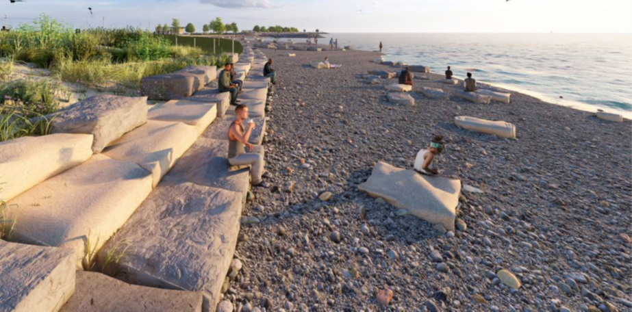
(Draft conceptual rendering of dynamic revetment with step stone reconstructed from original 1930's limestone blocks.)

Project Description and Background
The Morgan Shoal Revetment Reconstruction Project is located along the Lake Michigan shoreline between 45th and 51st Streets. This project is the latest phase of the Chicago Shoreline Protection Project, a long-term shoreline reconstruction project undertaken by the Chicago Department of Transportation (CDOT), the Chicago Park District (CPD), and the U.S. Army Corps of Engineers (USACE).
The primary purpose of this federal action is to address ongoing erosion and coastal storm damage that have affected parkland and threaten the stability of U.S. Highway 41 (DuSable Lake Shore Drive) within the City of Chicago by installing revetments that are designed to manage wave attack and flooding potential. The shoreline protection along this project reach consists of remnants of the earliest limestone block and timber crib revetment which has deteriorated over the decades as seen by the rotting timber pilings, lost crib fill, voids, displaced and lost limestone blocks. Currently, 91% of the revetment along this reach has experienced structural or functional failure that has led to wave overtopping, backshore erosion, and continued revetment deterioration.
Temporary emergency repair measures have been performed by the Chicago Park District over the years and most recently in 2020, but these areas remain distressed in the face of recent near-record lake elevations and storms and lack long-term constructed solutions. Due to the loss of parkland and proximity of DuSable Lake Shore Drive (within 150 feet of the water’s edge), a major transportation artery in the City of Chicago, it is necessary to perform construction of a long-term and complete replacement of existing failing revetment structures.
The proposed action is an evolved iteration of the 2015 Morgan Shoal Framework Plan, influenced by physical and computational coastal engineering modeling, community input, and agency coordination. Generally, the coastal structure would include a combination of rubble mound and dynamic revetment, stepped stone blocks, and a transitional section of steel sheet pile and concrete revetment to connect to the existing structure at 51st Street. The project would add up to approximately seven acres of new usable parkland by providing more width to the narrowest parts of the park.
The near-offshore geologic feature known as Morgan Shoal, that was once a Siliurian reef 425 million years ago, is a dolomitic limestone bedrock formation that offers unique aquatic habitat in Lake Michigan and presents construction constraints for modern revetments. The shallow bedrock along the project reach makes steel sheet pile-based shoreline revetments (as seen north of 45th Street and south of 51st Street) difficult to construct. Therefore, it presents an opportunity for alternative shore protection measures as described in the 2015 Morgan Shoal Framework Plan. See the Chicago Park District website for more information: https://assets.chicagoparkdistrict.com/s3fs-public/documents/page/Burnham_Park_-_Morgan_Shoal_Framework_Plan_%28Final%29.pdf
Current Status
The project design is currently in progress with the Public Building Commission of Chicago (PBC) as the managing partner for the development of planning, design, procurement and construction of the Morgan Shoal Revetment Reconstruction project. Please see their project page for more information: https://pbcchicago.com/projects/morgan-shoal-project/
The USACE is currently conducting an assessment of environmental impacts of the proposed action in accordance with the National Environmental Policy Act (NEPA). The USACE has initiated Section 106 consultation in coordination with the NEPA review process and coordination with the State Historic Preservation Office (SHPO) is ongoing.
A draft NEPA document was made available for public review on September 10, 2025 for public comment. The original October 2025 public meeting was postponed due to the lapse in government funding and has been rescheduled. The public review period remains open and will close after the public meeting has been held.
Project Authorization
The project is a segment of the Chicago Shoreline Protection Project (Interim III). Under resolutions adopted by the Committee on Public Works of the U.S. House (dated December 2, 1971 and April 11, 1974), USACE was directed to study shore erosion problems and erosion control measures for the Illinois shore of Lake Michigan.
Section 101(a)(12) of the Water Resources Development Act (WRDA) of 1996 authorized construction of the Chicago Shoreline Project. A project cooperation agreement (PCA) was executed on May 17, 1999, and provided for the non-Federal sponsor (the City of Chicago and the Chicago Park District) to build specific segments of the project.
NEPA Public Review
As part of the public review process, USACE would appreciate any comments associated with potential effects to environmental and cultural resources related to the proposed action. Submit comments through the comment form or crowd source mapping tool below. Emailed comments should be sent to morganshoalnepa@usace.army.mil
Public review closes: March 27th, 2026
Comment form: https://forms.osi.apps.mil/r/xYZUr1yx9G
Crowdsource mapping tool: https://usace-lrc.maps.arcgis.com/apps/instant/reporter/index.html?appid=c6778ad2d85c4b5699413055e46d05f4
The crowd source mapping tool allows the user to submit location-based comments pertaining to the proposed action.
Instructions: For best results, use Google Chrome. Once you open the tool, click on Proceed as Guest to open a map of the shoreline, click the X to close the help pop-up message. You can then navigate and zoom in to a specific location. To submit a comment, click on the map to add a location and fill out the comment form on the side of the page. Click the 'Submit a Comment' button to add your comment when it is complete. You can also view previous comments.
To view or hide the proposed features layer, select the  “open layer list” in the upper right corner and select or deselect the eye on the right
Let’s keep it civil. We ask that comments be pertinent to the study and appropriate for reading by all.
Application Disclaimer
All comments will be part of the public record and can be released under the Freedom of Information Act.
Maps are for graphical purposes only. They do not represent a legal survey. While every effort has been made to ensure that these data are accurate and reliable, within the limits of the current state of the art, USACE - Chicago District cannot assume liability for any damages caused by any errors or omissions in the data, nor as a result of the failure of the data to function on a particular system. USACE - Chicago District makes no warranty, expressed or implied, nor does the fact of distribution constitute such warranty.