Search

Cagles Mill Lake Master Plan Update

Louisville District
Published April 16, 2024

Cagles Mill Lake Master Plan Update

LOUISVILLE DISTRICT

Aerial view of the dam at Cagles Mill Lake in Poland, Indiana.
Cagles Mill Lake
Aerial view of the dam at Cagles Mill Lake in Poland, Indiana.
Photo By: USACE
VIRIN: 240116-A-A1409-1005

The Louisville District hosted a Public Workshop for the Cagles Mill Lake Master Plan Update May 9, 2024.

Public input is critical in the Master Plan update process. If you have any questions or want to submit comments, scan the QR code or click the button below.

QR code to submit comments for Cagles Mill Master Plan Update

General Information
The U.S. Army Corps of Engineers (USACE), Louisville District, is revising the Cagles Mill Lake Master Plan. The Master Plan is intended to serve as a comprehensive land and recreational management plan with a life span of 25 years. It guides the stewardship of natural and cultural resources and the provision of outdoor recreation facilities and opportunities to ensure sustainability of federal land associated with Cagles Mill Lake.

About Cagles Mill Lake
Cagles Mill Lake was authorized under the Flood Control Act of 1938. The Louisville District of the U.S. Army Corps of Engineers designed, built, and operates the project primarily for flood control in the Eel and White river watershed and forms an integral unit of the comprehensive flood control plan for the Ohio and Mississippi rivers. The lake lies in Putnam and Owen counties in south-central Indiana, approximately midway between Indianapolis and Terre Haute. The dam is located on Mill Creek 2.8 miles above its mouth. The 1,400-acre Cagles Mill Lake provides a wide variety of outdoor recreational opportunities. The Corps, in cooperation with the Indiana Department of Natural Resources, manages Cagles Mill Lake’s land and water for wildlife, fisheries and recreation. 

What is a Master Plan?
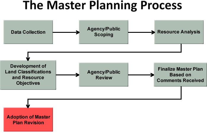
A Master Plan is the document that conceptually establishes and guides the orderly development, administration, maintenance, preservation, enhancement, and management of all natural, cultural, and recreational resources of a Corps water resource project.  A Master Plan is a land use management document.  It is focused on the operations and maintenance of an existing project and is no longer a “new project” document.   Master Plans do not include water management operations and associated prime facilities (dam, gates, powerhouses, spillways, etc.).  Of critical importance is the need to emphasize that a Master Plan is stewardship driven and must seek to balance recreational development and use with protection and conservation of natural and cultural resources. 

Why do we need a new Master Plan?
The current Cagles Lake Master Plan was completed in 1979, and has been used as a guide for recreational and environmental stewardship decisions. The Plan and the land classifications are in need of revision to address changes in regional land use, population, outdoor recreation trends and USACE management policy. Key topics to be addressed in the revised Master Plan include revised land classifications, new natural and recreational resource management objectives, recreation facility needs and special topics such as invasive species management and threatened and endangered species habitat. Public participation is critical to the successful revision of the Master Plan.

Public Involvement in Master Planning Process
Public participation will be a priority in the current Master Planning process.  We will be seeking public input from key stakeholders and partners.  In addition, open houses or public meetings will also be utilized to gather input from the general public.  We really want to know what you want, what your vision is for the future management of recreation and environmental stewardship programs might be, etc.  

Master Plan Classification
The master plan identifies classification (i.e. zoning) for the lakes. Public lands are allocated and classified into management categories which, based upon resources available and public needs, will provide for full utilization while protecting project resources. This zoning determines what types of development are permitted – for instance campgrounds are permitted in intensive use areas but not wildlife management zones.  The original Master Plan used slightly different zoning terminology than the new plan will use and also included detailed construction diagrams for campgrounds, picnic areas etc., and this level of detail will not be outlined in the new plan.

We will again re-assess the project’s environmental attributes, public needs, etc. but will not be producing detailed site designs.  Instead the focus will be on gathering public input and developing detailed natural resource inventories to guide in reassessing the future recreational needs and desired future conditions for natural resources.

Resources

*If you are looking for a document that you cannot locate on this page, please email lrl-pao@usace.army.mil.

Master Planning Process

Master Planning Process


Contact
Louisville District Public Affairs
lrl-pao@usace.army.mil
or
Project Delivery Team
caglesmill.masterplan@usace.army.mil

ArticleCS - Dashboard

Buckhorn, Kentucky
3/7/2025
 Buckhorn Lake (Eastern Kentucky) Flood Event Frequently Asked Questions (FAQs)The U.S. Army Corps of Engineers Louisville District is committed to providing clear communication and resources as you...
Chicago, IL
3/7/2025 UPDATED
                                                                                                                                                                (Draft conceptual rendering of dynamic...
Johnson County, KY Section 202 Flood Risk Management Project
3/3/2025
The U.S. Army Corps of Engineers is working in close coordination with the Johnson County Fiscal Court and City of Paintsville officials on the Johnson County Flood Risk Management Project, which is...
Nike SL-10, Marine, Illinois
1/23/2025 UPDATED
The former Nike SL-10 Launch Area is located approximately 3 miles north of the town of Marine in Madison County, Illinois.  The Launch Area is 19.87 acres in size, and includes the missile assembly...
Eastern Kentucky
11/14/2024
BackgroundFrom July 26 to July 30, 2022, upwards of 14-16 inches of rain fell in the Upper Kentucky River Basin area, which led to significant flooding on many rivers in eastern KY. Entire homes and...
Chemical Warfare Development Division, Michigan
9/17/2024 UPDATED
Chemical Warfare Development Division was used to secure and develop mustard agent from February 1918 until October 1918. The Chemical Warfare Development Division property was then transferred back...
U.S. Coast Guard Air Station/Cherry Capital Airport, Traverse City, Michigan
9/17/2024 UPDATED
U.S. Coast Guard Air Station/Cherry Capital Airport was used for military operations from 1946 until 1945. The property has been transferred to other government agencies and private parties.U.S. Coast...
West Virginia Maneuver Area/Dolly Sods
9/17/2024 UPDATED
West Virginia Maneuver Area/Dolly Sods was used for military training from 1943 until 1945. After West Virginia Maneuver Area/Dolly Sods the property was transferred to other government agencies and...
Grand Rapids National Guard Target Range, Kent County, Michigan
9/17/2024 UPDATED
Grand Rapids National Guard Target Range – Small Arms Target Range was used for military training from 1907 until 1976. Grand Rapids National Guard Target Range was closed in 1972. The property was...
Green River Ordnance Plant, Lee County, Illinois
9/17/2024 UPDATED
Green River Ordnance Plant was used for military ordnance storage from 1943 until 1945. After Green River Ordnance Plant was closed, the property was transferred to multiple private and public...
Illinois Ordinance Plant, near Marion, Illinois
9/17/2024 UPDATED
The U.S. Army Corps of Engineers updated the application of the Munitions Response Site Prioritization Protocol at Illinois Ordnance Plant (Crab Orchard). Illinois Ordnance Plant (Crab Orchard) was...
Lockbourne Air Force Base, Columbus, Franklin and Pickaway Counties, Ohio
9/17/2024 UPDATED
The former Lockbourne Air Force Base is a formerly used defense site located in Columbus, Franklin and Pickaway Counties, Ohio. The Louisville District is currently conducting several different...
Fort Custer, Michigan
9/17/2024 UPDATED
The former Fort Custer was established in 1917 for the induction and training of military personnel during World War (WW) I, WWII, and for a short time during the Korean War. At the height of its use,...
Erie Army Depot, Carroll Township, Ottawa County, Ohio
9/17/2024 UPDATED
The former Erie Army Depot is a formerly used defense site located in Carroll Township, Ottawa County, Ohio.The former Erie Army Depot (EAD) was an artillery and air-defense artillery proving ground...
Camp Sherman, Franklin Township, Ross County, 7 miles south of Chillicothe, Ohio
9/17/2024 UPDATED
The former Camp Sherman consists of 4,883 acres of land in Franklin Township, Ross County located approximately 7 miles south of Chillicothe, Ohio. The Camp Sherman Artillery Range MRS (Munitions...
Camp Ellis, near Table Grove, Illinois
9/17/2024 UPDATED
Camp Ellis was once a World War II Army Training Center. A Decision Document was finalized in 2016 by the U.S. Army Corps of Engineers (USACE) Louisville District at the former camp located near Table...
Camp Breckinridge, Morganfield, Kentucky
9/17/2024 UPDATED
Public Meeting InformationThe public meeting will be held Tuesday, December 17, 2024, at 5:00 p.m. (CST) at the Camp Breckinridge Museum and Arts Center, 1116 Village Square Road, Morganfield, KY...
Camp Grant Rifle Range, Winnebago County, Illinois
9/17/2024 UPDATED
HistoryThe former Camp Grant was located northwest of Chicago near Rockford in Winnebago County. During WWI, the camp included such buildings as barracks, a headquarters building, a cavalry remounting...
Kenosha County, Wisconsin
9/10/2024 UPDATED
The South Branch Pike River is in a rapidly urbanizing watershed with substantial urban and agricultural lands.The purpose of the project is to restore approximately 246 acres of habitat through...
Chickamauga Lock Replacement Project
6/20/2024
Replacing a lock vital to maintaining 318 miles of navigable upstream channels...
Allegheny River Lock and Dam 3
5/15/2024
1 Barking Road, New Kensington, PA 15068 | (412) 828-3550...
Black Rock Lock
4/10/2024 UPDATED
The Black Rock Channel extends from Buffalo Harbor to the Black Rock Lock.  It is three and one-half miles in length.  The Federal navigation channel has a minimum width of 200 feet. Pleasure craft...
Patoka Lake Master Plan Update
3/25/2024
 The U.S. Army Corps of Engineers has updated its 1974 Master Plan for Patoka Lake.The 2025 final Master Plan and Environmental Assessment for Patoka Lake is available here. General InformationThe...
History of Bluestone Dam
3/18/2024
History of Bluestone DamDescriptionLOCATION:Hinton vicinity on the New River, approximately 65 miles above the river's mouthSTRUCTURE:straight concrete gravity damOVERALL LENGTH:2,048 feetMAXIMUM...
Shenango River Lake Master Plan
2/23/2024
Mitigating flooding for the Shenango River Valley, as well as for the Beaver and upper Ohio rivers...
Phosphorus Optimal Wetland Demonstration
2/8/2024 UPDATED
Funded through the Great Lakes Restoration Initiative, this project employs a novel approach to improve Great Lakes tributary water quality based on the construction of a wetland system in a location...
Phosphorus Optimal Wetland Demonstration
2/8/2024 UPDATED
Funded through the Great Lakes Restoration Initiative, this project employs a novel approach to improve Great Lakes tributary water quality based on the construction of a wetland system in a location...
Lake Ontario Ordnance Works (LOOW), Lewiston, New York
2/1/2024 UPDATED
In 1941 the Department of Defense (DOD) purchased 7,500 acres of land in Niagara County, on which was built the former Lake Ontario Ordnance Works (LOOW), for the purpose of manufacturing...
Huntington District Water Resource Project Agreements
1/23/2024
  Huntington District Project Partnership Agreements
Great Lakes Confined Disposal Facilities
1/18/2024
A confined disposal facility, or CDF, is a structure planned and designed to receive sediments dredged from a navigation channel and safely contain the contaminants, preventing their reentry into the...
Tar Pamlico Basin Flood Risk-Management Study
1/17/2024
Assessing and recommending actions that reduce flood risk and increase resiliency within the Tar-Pamlico River Basin...
Shallow Land Disposal Area
1/17/2024 UPDATED
Remediating and cleaning up an area affected by the nation's atomic weapons and energy programs...
Upper Ohio River Navigation Project
1/17/2024
Revitalizing the oldest and smallest locks in the entire Ohio River navigation system - the Emsworth, Dashields and Montgomery locks and dams...
Whitefish Point Harbor, Michigan
1/16/2024
Whitefish Point is located on the south shore of Lake Superior 40 miles northwesterly from Sault St. Marie, Michigan and 53 miles easterly from Grand Marais...
White Lake Harbor, Michigan
1/16/2024
White Lake Harbor, Michigan is located on the east shore of Lake Michigan, about 120 miles northeasterly from Chicago, Illinois, and 45 miles southerly from Ludington, Michigan...
Tawas Bay Harbor, Michigan
1/16/2024
On the northeasterly portion of Saginaw Bay, an arm of Lake Huron, adjacent to Tawas, Michigan. Authorized by the Rivers and Harbors Act of 13 August 1968...
Taconite Harbor, Minnesota
1/16/2024
Taconite Harbor is a Minnesota DNR Harbor...
St Marys River, Michigan
1/16/2024
The St. Marys River, Michigan is a Great Lakes connecting channel about 63 miles long, flowing southeasterly between the State of Michigan and Province of Ontario, Canada, from the eastern end of Lake...
St. James Harbor, Beaver Island, Michigan
1/16/2024
St. James Harbor, Beaver Island, Michigan is located in St. James Bay on Beaver Island, Michigan in Lake Michigan, about 31 miles northwesterly from Charlevoix, Michigan...
South Haven Harbor, Michigan
1/16/2024
South Haven Harbor, Michigan is located on the east shore of Lake Michigan, 77 miles northeasterly from Chicago, Illinois, and 24 miles northerly from St. Joseph, Michigan...
Silver Bay Harbor, Minnesota
1/16/2024
Silver Bay Harbor is a Minnesota DNR Harbor...
Sebewaing River, Michigan
1/16/2024
Sebewaing River is located on Saginaw Bay in the thumb of Michigan, on the west shore of Lake Huron, about 20 miles northeast of the mouth of the Saginaw River. Michigan,...
Saxon Harbor, Wisconsin
1/16/2024
Authorized by River and Harbors Act of 1958. Provides for east and west breakwaters, and outer channel 10 feet deep, and inner basin and side channel 8 feet deep...
Saugatuck Harbor, Michigan
1/16/2024
Saugatuck Harbor, Michigan is located on the east shore of Lake Michigan, about 90 miles northeasterly from Chicago, Illinois and 22 miles northerly from South Haven, Michigan...
Saginaw River, Michigan
1/16/2024
Saginaw River, Michigan is formed by union of the Tittabawassee and Shiawassee Rivers, 22 miles long, and flows northerly into the extreme inner end of Saginaw Bay, Lake Huron...
Portage Lake Harbor, Michigan
1/16/2024
Portage Lake Harbor, Michigan is located on the west shore of Lake Michigan, about 186 miles northeasterly from Chicago, Illinois, and about 37 miles northerly from Ludington, Michigan...
Port Wing Harbor, Wisconsin
1/16/2024
Port Wing Harbor, Wisconsin is located on the south shore of Lake Superior, about 34 miles easterly from Duluth, Minnesota...
Port Sanilac Harbor, Michigan
1/16/2024
Port Sanilac Harbor, Michigan is located on the west shore of Lake Huron, about 30 miles north of Port Huron, Michigan...
Port Austin Harbor, Michigan
1/16/2024
Shallow draft recreation harbor located on Lake Huron at the tip of the thumb of Michigan, about 80 miles northeast of Saginaw, MI...
Hydropower
1/12/2024
The Nashville District Hydropower Program began under the Flood Control Act of 1938, which authorized minimum provisions for hydropower at flood control projects.  The first power plant constructed in...
Cordell Hull Navigation Lock
1/12/2024
Cordell Hull Navigation Lock is located near Carthage, Tenn., at river mile 313.5.Clear Chamber dimensions: 84 by 400 feetLift at normal pool levels: 59 feetMinimum lock filling time at normal head:...
Old Hickory Navigation Lock
1/12/2024
Old Hickory Lock is located at Mile 216.2 on the Cumberland River and is approximately 11.5 miles northeast of Nashville, TN.  Old Hickory Lock is open to pass navigation traffic 16 hours a day, 365...
Cheatham Navigation Lock
1/12/2024
Cheatham Navigation LockCheatham Lock is located at Mile 148.6 on the Cumberland River in Cheatham County, Tennessee and is approximately 10 miles northwest of Ashland City, Tenn.  Cheatham Lock is...
Barkley Navigation Lock
1/11/2024
Barkley Navigation LockBarkley Lock is located 30.6 river miles from where the Cumberland River joins the Ohio River at Smithland, Kentucky.  The nearest community to the lock is Grand Rivers,...
Downloadable Tennessee River Charts
1/11/2024
Charts are in PDF format. You must have Adobe Acrobat Reader installed on your computer to view and print the charts. Click on the chart number you wish to view.  The topographical background images...
USACE Environmental Operating Principles
1/11/2024
The U.S. Army Corps of Engineers (USACE) Environmental Operating Principles (EOPs) were developed to ensure that USACE missions include totally integrated sustainable environmental practices. The EOPs...
Fort Loudoun Navigation Lock
1/11/2024
Fort Loudoun Lock is located near Lenoir City, Tennessee, some 55 miles downstream from Knoxville.It is at Tennessee River mile 602.3, some 73.4 miles upstream of Watts Bar Lock.Fort Loudoun is the...
Watts Bar Navigation Lock
1/11/2024
Watts Bar Lock is near Decatur, Tennessee.  It is approximately halfway between Chattanooga and Knoxville.The lock is located at Tennessee River mile 529.9.  It is 72.4 miles downstream from Fort...
Point Lookout Harbor, Michigan
1/11/2024
Point Lookout Harbor, Michigan is located at the Au Gres River on the westerly shore of Lake Huron at the entrance to Saginaw Bay, about 17 miles northeast of the mouth of the Saginaw River...
Melton Hill Navigation Lock
1/11/2024
  Melton Hill Lock is  nine miles southwest of Oak Ridge, Tenn., and 19 miles west of Knoxville.Located 23.1 miles from the confluence of the Clinch with the Tennessee River, it is the only Corps lock...
Pine River, Michigan
1/11/2024
Authorized by the Rivers and Harbors Act of 3 June 1896. Provides for a channel 100 feet wide and 14 feet deep...
Petoskey Harbor, Michigan
1/11/2024
Petoskey Harbor, Michigan is located on the east shore of Lake Michigan about 50 miles south of the Straits of Mackinac...
Pentwater Harbor, Michigan
1/11/2024
Pentwater Harbor, Michigan is located on the east shore of Lake Michigan, 146 miles northeasterly from Chicago, Illinois and 14 miles southerly from Ludington, Michigan...
New Buffalo Harbor, Michigan
1/11/2024
New Buffalo Harbor, Michigan is located at the mouth of the Galien River on the southeast shore of Lake Michigan in Berrien Country, about 45 miles easterly from Chicago, Illinois...
Menominee Harbor, Michigan and Wisconsin
1/11/2024
Menominee Harbor, Michigan & Wisconsin is located on Lake Michigan at the mouth of the Menominee River on the western shore of Green Bay, 16 miles northwest of the mouth of Sturgeon Bay, and 49 miles...
McQuade Harbor, Minnesota
1/11/2024
McQuade Harbor is a Minnesota DNR Harbor...
Chickamauga Navigation Lock
1/11/2024
Chickamauga Lock is  located at Tennessee River mile 471 only 6.9 miles above Chattanooga, Tennessee.It is 58.9 river miles downstream of Watts Bar Lock and 46.3 miles upriver from Nickajack Lock.Lock...
Manistique Harbor, Michigan
1/11/2024
Manistique Harbor, Michigan is located on the north shore of Lake Michigan, 135 miles northeasterly from Green Bay Harbor, WI, and 220 miles northerly from Milwaukee, WI...
Mackinaw City Harbor, Michigan
1/11/2024
Shallow draft recreational harbor...
Nickajack Navigation Lock
1/11/2024
Nickajack Lock is located 35 miles west of Chattanooga, Tennessee near the city of Jasper.The lock is at river mile 424.7.  It is 46.3 miles below Chickamauga Lock and 75.3 miles above Guntersville...
Mackinac Island Harbor, Michigan
1/11/2024
Mackinac Island Harbor is a recreational harbor located on the southeast side of Mackinac Island, which lies just east of the Straits of Mackinac, the connecting waterway between Lakes Michigan and...
Guntersville Navigation Lock
1/11/2024
Guntersville Lock is located at Tennessee River mile 349, nine miles downstream from the city of Guntersville, Alabama.It is 75.3 miles downstream from Nickajack Lock and 74.1 miles above the Wheeler...
Lexington Harbor, Michigan
1/11/2024
Lexington Harbor, Michigan is located on the west shore of Lake Huron, about 20 miles north of Port Huron, Michigan...
Les Cheneaux Islands, Michigan
1/11/2024
Shallow draft recreational harbor with a 7 foot project depth...
Leland Harbor, Michigan
1/11/2024
Leland Harbor, Michigan is located on the west shore of Lake Michigan, at the mouth of the Carp River, about 40 miles north of Frankfort, Michigan and 40 miles southwest of Charlevoix, Michigan...
Lac La Belle Harbor, Michigan
1/11/2024
Located in the northeastern tip of thye Keweenaw Peninsula off the shore of Lake Superior. Shallow draft recreation harbor with project depths of 10 and 12 feet...
La Pointe Harbor, Wisconsin
1/11/2024
Shallow draft recreation harbor with a 10 foot project depth...
Knife River Harbor, Minnesota
1/11/2024
Located on the north shore of Lake Superior about 18 miles northeast of Duluth, MN. Shallow draft recreational harbor with 8 and 10 foot project depths...
Wheeler Navigation Lock
1/11/2024
Wheeler Navigation LockThe Wheeler Locks are located about 30 miles from Decatur, Alabama. The locks are at river mile 274.9.  They are 15 miles above the Wilson Locks and 74.1 miles below...
Kawkawlin River, Michigan
1/11/2024
Kawkawlin River is located on the south shore of the Saginaw Bay on Lake Huron, 16 miles north of Saginaw, MI. Authorization: Section 13 of the 1946 Flood Control Act (FCA) - (Section A); and...
Wilson Navigation Lock
1/11/2024
Wilson Lock is located in the northwest corner of Alabama.Located at Tennessee River mile 259.4, the lock is 15 miles below the Wheeler Locks and 52.7 miles above Pickwick Lock.It is the highest...
Inland Route, Michigan
1/11/2024
The Inland Route, Michigan is a series of interconnected lakes and streams stretching across the northern tip of the Lower Peninsula of Michigan, and extends from Conway near Lake Michigan to...
Pickwick Lock
1/11/2024
Pickwick Navigation LockPickwick Lock is approximately 12 miles south of Savannah, Tennessee.  It is just north of the Mississippi state line.Located at Tennessee  River mile 206.7, it is 52.7 miles...
Harrisville Harbor, Michigan
1/11/2024
Harrisville Harbor, Michigan is located on the west shore of Lake Huron, 20 miles north of Oscoda and 30 miles south of Alpena...
Hammond Bay Harbor, Michigan
1/11/2024
Located on the western shore of Lake Huron, about 30 miles southeast of the Straits of Mackinac...
Grand Traverse Bay, Michigan
1/11/2024
Grand Traverse Bay Harbor, Michigan is located on the south shore of Lake Superior, at the mouth of the Traverse River on the eastern shore of Keweenaw Bay, about 20 miles northeasterly from the...
Kentucky Lock
1/11/2024
Kentucky Lock is located near Gilbertsville, Kentucky, 22.4 miles from the confluence of the Tennessee and Ohio Rivers.  It is 20 miles east of Paducah, Kentucky. The 184-mile reservoir created by...
Grand River, Michigan
1/11/2024
The Grand River is part of the Grand Haven Harbor, MI project...
Grand Marais Harbor, Minnesota
1/11/2024
Grand Marais Harbor, Minnesota is located on the north shore of Lake Superior, about 110 miles northeast of Duluth, Minnesota...
Wolf Creek Dam
1/11/2024
History of Wolf Creek DamThe Wolf Creek Project was authorized by the Flood Control Act of 1938 and the Rivers and Harbor Act of 1946.  Construction of the project, designed and supervised by the U.S...
Old Hickory Dam
1/11/2024
HistoryThe Old Hickory Lock and Dam, located on the Cumberland River at mile 216.2 in Sumner and Davidson Counties, Tennessee, and are approximately 25 miles upstream from Nashville, Tenn. The City of...
Martins Fork Dam
1/11/2024
HistoryMartins Fork Lake is located at river mile 15.6 on the Martins Fork of the Cumberland River in the scenic mountainous terrain of Harlan County, 13 miles southeast of the town of Harlan,...
Laurel River Dam
1/11/2024
Laurel River Lake is a key project in the development of the Cumberland River Basin.  The lake is located in southeastern Kentucky, encompassing portions of Laurel and Whitley Counties. In the 1960's,...
J. Percy Priest Dam
1/11/2024
J. Percy Priest Dam was built at mile 6.8 on the Stones River, a tributary of the Cumberland.  The lake is located in north central Tennessee, encompassing portions of Davidson, Rutherford, and Wilson...
Dale Hollow Dam
1/11/2024
Dale Hollow Dam is located approximately three miles east of Celina, Tennessee on the Obey River, 7.3 miles above its juncture with the Cumberland River at river mile 380.0. Dale Hollow Lake covers...
Cordell Hull Dam
1/11/2024
Cordell Hull Lake is located on the Cumberland River in Smith, Jackson, and Clay counties of Tennessee.  The dam is located at river mile 313.5, about five miles upstream of the city of Carthage,...
Eagle Harbor, Michigan
1/11/2024
On the south shore of Lake Superior on the North Face of Keweenaw Point, 31 miles northeasterly from the Upper Entrance of Keweenaw Waterway...
Cornucopia Harbor, Wisconsin
1/11/2024
Cornucopia Harbor, Wisconsin is located at the mouth of the Siskiwit River on the south shore of Lake Superior, 49 miles east from Duluth, MN...
Clinton River, Michigan
1/11/2024
Clinton River, Michigan has its sources in Oakland County, Michigan, flows easterly about 60 miles and empties into Anchor Bay in northwestern part of Lake St. Clair...
Chippewa Harbor, Michigan
1/11/2024
Chippewa Harbor is located in Isle Royale, MI in Keweenaw County (National Park) on Lake Superior...
Charlevoix Harbor, Michigan
1/11/2024
Charlevoix Harbor, Michigan is located on the east shore of Lake Michigan, 276 miles northeasterly from Chicago, IL, and 75 miles northerly from Frankfort, MI...
Lake St Clair, Michigan
1/11/2024
The Channels in Lake St. Clair, Michigan, a section of Great Lakes Connecting Channels, is a two-way vessel track with a length of about 15 miles located in the expansive shallow basin of Lake St...
Cedar River Harbor, Michigan
1/11/2024
Cedar River Harbor, Michigan is located on Green Bay off of Lake Michigan, about 25 miles northwest of Menominee, MI...
Caseville Harbor, Michigan
1/11/2024
Caseville Harbor, Michigan is located at mouth of the Pigeon River on the south shore of Saginaw Bay about 17 miles southwest of Port Austin, MI...
Bolles Harbor, Michigan
1/11/2024
Bolles Harbor, Michigan is located on the west shore of Lake Erie, at the mouth of La Plaisance Creek, 7 miles southwest of Monroe, Michigan...
Black River, Upper Peninsula, Michigan
1/11/2024
Black River Harbor, Michigan is located at the mouth of the Black River on the south shore of Lake Superior 39 miles westerly from Ontonagon, MI, and 47 miles easterly from Ashland, WI...
Cheatham Dam
1/11/2024
Cheatham Dam is located in Cheatham County, Tenn., on the Cumberland River at mile 148.7 about nine miles downstream of Ashland City.  It is about 42 miles downstream from Nashville.Cheatham Dam was...
Water Management - Chicago Area Waterway
1/11/2024
Chicago Area Waterway Stages and Flows...
Floodplain Management Services Program
1/11/2024
Most people know that the U.S. Army Corps of Engineers builds water resource projects, like dams and levees. Not so well known; however, is that the Corps also provides assistance to help states,...
New Lock at the Soo, Sault Ste. Marie, Michigan
1/10/2024 UPDATED
The Soo Locks facility, operated and maintained by the U.S. Army Corps of Engineers, Detroit District, is the district’s largest project and is located on the St. Marys River at Sault Ste. Marie,...
New Lock at the Soo
1/10/2024 UPDATED
The Soo Locks facility, operated and maintained by the U.S. Army Corps of Engineers, Detroit District, is the district’s largest project and is located on the St. Marys River at Sault Ste. Marie,...
Center Hill Dam
1/10/2024
Center Hill Dam is one of the multipurpose projects that make up the Corps of Engineers’ system for development of the water resources of the Cumberland River Basin. This system is an important part...
Youghiogheny River Lake
1/10/2024
Provides flood protection for the Youghiogheny and lower Monongahela river valleys, and the upper Ohio River...
Barkley Dam
1/10/2024
Barkley Dam is a concrete gravity and earthfill structure that measures 10,180 ft.  The powerplant section of the dam contains four generating units capable of producing 130,000 kilowatts.  The...
Woodcock Creek Lake
1/10/2024
Provides flood protection for the French Creek system...
Union City Dam
1/10/2024
Provides flood protection for the French Creek Valley, and to a lesser degree, the Allegheny River below Franklin, Pennsylvania...
Old Hickory Lake
1/10/2024
The U.S. Army Corps of Engineers Nashville District welcomes you to Old Hickory Lake.Located near Metropolitan Nashville, Tenn., the lake provides a variety of outdoor recreational opportunities for...
J. Percy Priest Lake
1/10/2024
The U.S. Army Corps of Engineers Nashville District welcomes you to J. Percy Priest Lake.  The lake provides a variety of outdoor recreational opportunities for millions of visitors each year...
Tygart Lake
1/10/2024
Provides flood protection for the Tygart River Valley, and the Monongahela and upper Ohio rivers...
Tionesta Lake
1/10/2024
A key link in a system of flood-control projects for the Allegheny and upper Ohio rivers...
Dale Hollow Lake
1/10/2024
The Nashville District of the U.S. Army Corps of Engineers welcomes you to Dale Hollow Lake. Dale Hollow Dam and Lake was authorized by the Flood Control Act of 1938 and the River and Harbor Act of...
Stonewall Jackson Lake
1/10/2024
Provides flood protection, low flow augmentation for water quality, water supply, fish and wildlife enhancement, hydropower and recreation...
Shenango River Lake
1/10/2024
Mitigates flooding for the Shenango River valley, as well as for the Beaver and upper Ohio rivers...
Cordell Hull Lake
1/10/2024
The Nashville District U.S. Army Corps of Engineers welcomes you to Cordell Hull Lake.  The lake provides a variety of outdoor recreational opportunities for millions of visitors each year.  Because...
Mosquito Creek Lake
1/10/2024
Provides flood protection for the Mahoning River Valley, as well as the Beaver and upper Ohio rivers...
Michael J. Kirwan Dam and Reservoir
1/10/2024
Provides flood protection for the Mahoning River Valley and the Beaver and upper Ohio River...
Mahoning Creek Lake
1/10/2024
Mahoning Dam provides flood protection for the lower Allegheny River Valley and the upper Ohio River...
Cheatham Lake
1/10/2024
The Nashville District U.S. Army Corps of Engineers welcomes you to Cheatham Lake.  The lake provides a variety of outdoor recreational opportunities for millions of visitors each year.  Because of...
Loyalhanna Lake
1/10/2024
Provides flood protection for the lower Loyalhanna Creek and Kiskiminetas River valleys, and the lower Allegheny and upper Ohio rivers...
Kinzua Dam & Allegheny Reservoir
1/10/2024
Kinzua Dam substantially reduces flooding in the Allegheny and upper Ohio river valleys, and Warren, Pennsylvania...
Center Hill Lake
1/10/2024
Draft Shoreline Management Plan - View Shoreline Management Plan News Release - View  The Nashville District U.S. Army Corps of Engineers welcomes you to Center Hill Lake.  The lake provides varied...
East Branch Clarion River Lake
1/10/2024
A key project in a system reducing flooding in the Allegheny and upper Ohio rivers, Clarion River valley, and the Johnsonburg and Ridgway boroughs...
Crooked Creek Lake
1/10/2024
Crooked Creek Lake is an important link in a system of flood-control projects and provides flood protection for the lower Allegheny and Ohio rivers...
Conemaugh River Lake
1/10/2024
Provides flood protection for the lower Conemaugh Valley, the Kiskiminetas Valley, the lower Allegheny Valley, and the upper Ohio River Valley...
William H. Harsha Lake
1/10/2024
Welcome to the William H. Harsha Lake (also known as East Fork). The lake is situated in Clermont County in southwestern Ohio, about 25 miles east of Cincinnati.   The dam is about four miles south of...
Sutton Lake
1/10/2024
Sutton Lake covers 1440 acres. It is a beautiful lake, winding 14 miles along the Elk River, with many coves along its 40 miles of shoreline. The lake is 125 feet deep at the dam. Sutton Dam is...
Berlin Lake
1/10/2024
Berlin Lake provides flood protection for the Mahoning River Valley as well as for the Beaver and upper Ohio rivers...
Summersville Lake
1/10/2024
Summersville Dam was authorized by Section 4 of Flood Control Act of 1938. The primary project purposes are flood risk management, fish and wildlife enhancement, water quality, recreation, and low...
Taylorsville Lake
1/10/2024
Welcome to Taylorsville Lake. The Lake is located on the Salt River beginning at river mile 78 about 5 miles west of Glensboro and extends downstream to the dam at river mile 60.  The Lake is 18 miles...
R.D. Bailey Lake
1/10/2024
This project was called the Justice Reservoir, during the planning stages. In 1965, Congress changed the name in honor of the late Judge R.D. Bailey, a lawyer, state senator, prosecuting attorney, and...
East Lynn Lake
1/10/2024
East Lynn Lake is located on the East Fork of Twelvepole Creek, 10 miles south of Wayne, WV, on State Route 37. East Lynn Lake was constructed primarily for flood control, water quality, fish...
Burnsville Lake
1/10/2024
Burnsville Dam is located in Braxton County on the Little Kanawha River, 124 miles above its confluence with the Ohio River and approximately 3 miles above the Town of Burnsville, West Virginia...
Cave Run Lake
1/10/2024
Welcome to the Cave Run Lake. The lake is located within the scenic Eastern Highlands Region of Kentucky and is almost completely surrounded by the northern-most section of the Daniel Boone National...
Caesar Creek Lake
1/10/2024
Welcome to the Caesar Creek Lake. The lake is located in Warren, Clinton and Greene counties in southwestern Ohio. The dam is three miles above the mouth of Caesar Creek, a tributary of the Little...
Bluestone Dam
1/10/2024
Bluestone Lake was authorized by Section 5 of the Flood Control Act of 1936, amended by section 4 of the FCA of 1938. The primary project purposes are flood risk management, fish and wildlife...
Carr Creek Lake
1/10/2024
Welcome to the Carr Creek Lake. The lake is located in the mountainous region of southeastern Kentucky, about 16 miles from Hazard and 18 miles from Whitesburg. The dam is located 8.8 miles above the...
Black River, Port Huron, Michigan
1/10/2024
The Black River has its source in the northern part of Sanilac County, MI, is about 60 miles long, and flows in a southeasterly direction into the St. Clair River at Port Huron, MI...
Beech Fork Lake
1/10/2024
Beech Fork Lake (authorized by the Flood Control Act of 1962) is part of the integrated flood reduction system operated by the Corps of Engineers for the entire Ohio River Basin. When these lakes are...
North Fork of Pound River Lake
1/10/2024
The North Fork of Pound River is a part of the upper reaches of the Big Sandy system.  On its way to the Ohio River, the waters from North Fork flow northeast and meet the South Fork River to form the...
Big Bay Harbor, Michigan
1/10/2024
Big Bay Harbor, Michigan is located on the south shore of Lake Superior, 33 miles northwesterly from Marquette, Michigan, and 38 miles easterly from the Portage entry to the Keweenaw Waterway...
John W. Flannagan Lake
1/10/2024
Authorized by Congress in the Flood control Act of 1938, and the Federal Water Pollution Control Act Amendments of 1961, John W. Flannagan Dam and Reservoir is a part of the Big Sandy flood protection...
Belle River, Michigan
1/10/2024
Authorized project depths are 14 feet and 15 feet...
Bayfield Harbor, Wisconsin
1/10/2024
Located on the south shore of Lake Superior, 85 miles east of Duluth, MN...
Bayport Harbor, Michigan
1/10/2024
Bay Port Harbor, Michigan is located on Wild Fowl Bay on the east shore of Saginaw Bay about 10 mile south of Caseville, MI...
Cagles Mill Lake
1/10/2024
Welcome to the Cagles Mill Lake. The lake lies in Putnam and Owen counties in south-central Indiana, approximately midway between Indianapolis and Terre Haute. The area is picturesque with rolling...
Soo Locks, Sault Ste. Marie, Michigan
1/10/2024 UPDATED
The Soo Locks at Sault Ste. Marie, Michigan are among the busiest lock systems in the world. Operated and maintained by U. S. Army Corps of Engineers, Detroit District. The locks are a National...
Wills Creek Dam
1/10/2024
Wills Creek Lake, was authorized for flood control and allied purposes by the official plan for the Muskingum reservoir system prepared by the U.S. Army Corps of Engineers, and approved on November...
Buckhorn Lake
1/10/2024
Welcome to the Buckhorn Lake. The lake is situated in Leslie and Perry counties on the Middle Fork of the Kentucky River in the foothills of the Cumberland Plateau, offering the scenic beauty of the...
Tom Jenkins Dam
1/10/2024
Tappan Lake is within the Lower Tuscarawas section of the Muskingum Area. It was authorized by Section 4 of the Flood Control Act (FCA) of 1938, as amended by Section 4 of the FCA of 1939. Primary...
Hannibal Locks and Dam
1/10/2024
P.O. Box 8, Hannibal, OH 43931-0008 | 740-483-2305 ...
Rough River Lake
1/10/2024
Welcome to Rough River Lake. The lake is situated in Breckinridge, Hardin, and Grayson counties in south central Kentucky. The dam is located on the Rough River near the community of Falls of Rough,...
Tappan Lake
1/10/2024
Tappan Lake is within the Lower Tuscarawas section of the Muskingum Area. It was authorized by Section 4 of the Flood Control Act (FCA) of 1938, as amended by Section 4 of the FCA of 1939. Primary...
Pike Island Locks and Dam
1/10/2024
RR #1, Box 33, Wheeling, WV 26003-9701 | 304-277-2127 ...
Senecaville Lake
1/10/2024
Senecaville Lake is within the Lower Tuscarawas section of the Muskingum Area and is one of a system of projects designed to provide flood control and water conservation in the Muskingum Watershed in...
Pleasant Hill Lake
1/10/2024
The U.S. Army Corps of Engineer's Pleasant Hill Dam is right in the middle of two major recreation areas; Mohican State Park and Mohican Memorial Forest below the dam and MWCD's Pleasant Hill Lake...
Piedmont Lake
1/10/2024
Piedmont Dam is located near the southern border of Harrison County, Ohio, on Stillwater Creek, a tributary of the Tuscarawas River.  At summer elevation the Piedmont Lake pool covers 2,312 acres over...
Paint Creek Lake
1/10/2024
The lake provides flood control (authorized by the Flood Control Act of 1938) for the communities along Paint Creek. In addition, it provides water supply for Highland Water Company, increases water...
North Branch Kokosing River Lake
1/10/2024
Kokosing Dam was built by the U.S. Army Corps of Engineers for flood control, recreation and wildlife management.  Construction began in June 1970 and was completed in May 1972. The dam has an...
Mohicanville Dam
1/10/2024
Built in 1935, Mohicanville Dam, a flood control project, is a dry dam with no permanent pool. The dam site is located on the Lakefork of the Mohican River in northeast Ohio, 171 miles above the mouth...
Mohawk Dam
1/10/2024
Mohawk Dam was authorized by the Flood Control Act of 1938 and was built along with 13 other dams to control flooding within the Muskingum River watershed.  Work began in April 1935 and the dam was...
New Cumberland Locks and Dam
1/10/2024
P.O. Box 159, Stratton, OH 43961-0159 | 740-537-2571 ...
Montgomery Locks and Dam
1/10/2024
100 Montgomery Dam Road, Monaca, PA 15061-2221 | 724-643-8400 ...
Leesville Lake
1/10/2024
In Carroll County, Ohio, Leesville Lake is on McGuire Creek, a tributary of Conotton Creek on Tuscarawas River, which runs into the Muskingum River. Leesville Lake was constructed primarily for flood...
Dashields Locks and Dam
1/10/2024
100 Dashields Lock Road, Coraopolis, PA 15108-5417 | 724-457-8430 ...
Dover Dam
1/10/2024
Dover Dam is located in Tuscarawas County, Ohio, in the Tuscarawas River, approximately three and one-half miles northeast of Dover, Ohio. Dover Dam is a concrete gravity structure with a maximum...
Emsworth Locks and Dams
1/10/2024
0 Western Avenue, Pittsburgh, PA 15202-1708 | 412-766-6213 ...
Dillon Lake
1/10/2024
Naming of Dillon Lake followed a long standing US Army Corps of Engineers tradition of naming the lake after the closest town. Dillon was started by Moses Dillon, a Quaker from Maryland. While on his...
Delaware Lake
1/10/2024
Delaware Lake is part of a system of dams that reduce flood stages in the Olentangy, Scioto, and Ohio River Basins; benefiting communities and agricultural lands between Delaware and the Gulf of...
Opekiska Lock and Dam
1/10/2024
1241 Opekiska Road, Fairmont, WV 26554-8612 | 304-366-4224 ...
Deer Creek Lake
1/10/2024
Deer Creek Lake  was authorized by Section 4 of Flood Control Act of 1938. The primary project purposes are flood risk reduction, fish and wildlife enhancement, recreation, and low flow augmentation...
Hildebrand Lock and Dam
1/10/2024
1610 Hildebrand Lock and Dam Road, Morgantown, WV 26501-7643 | 304-983-2300 ...
Morgantown Lock and Dam
1/10/2024
26 Morgantown Lock Road, Morgantown, WV 26501-2329 | 304-292-1885...
Clendening Lake
1/10/2024
Clendening Lake is located in Harrison County, Ohio on the Brushy Fork of the Stillwater Creek within the Lower Tuscarawas section of the Muskingum Area. Clendening Lake was constructed in 1937.  It...
Point Marion Lock and Dam
1/10/2024
304 Powerplant Road, Dilliner, PA 15327-9603 | 724-725-5289...
Charles Mill Lake
1/10/2024
Charles Mill Dam is located on the Black Fork of the Mohican River, 10 miles east of Mansfield and 10 miles southwest of Ashland, Ohio. The lake is located in Ashland and Richland counties with the...
Grays Landing Lock and Dam
1/10/2024
599 Broadway Street, Masontown, PA 15461-0671 | 724-583-8304 ...
Bolivar Dam
1/10/2024
Bolivar Dam is within the Upper Tuscarawas section of the Muskingum Area. It was authorized by Section 4 of the Flood Control Act (FCA) of 1938, as amended by Section 4 of the FCA of 1939. Primary...
Maxwell Locks and Dam
1/10/2024
142 Maxwell Locks and Dam, E. Millsboro, PA 15433-1261 | 724-785-5027 ...
Beach City Lake
1/10/2024
Beach City Dam is located near the northern border of Tuscarawas County, Ohio, on Sugar Creek, a tributary of the Tuscarawas River, about nine miles above New Philadelphia, Ohio. The dam was completed...
John P. Murtha Locks and Dam
1/10/2024
1900 Gibsonton Road, Belle Vernon, PA 15012-4514 | 724-684-8442 ...
Atwood Lake
1/10/2024
Atwood Lake serves as the Project Office for the projects located within the Lower Tuscarawas section of the Muskingum Area. It was authorized by Section 4 of the Flood Control Act (FCA) of 1938, as...
Barren River Lake
1/10/2024
Welcome to Barren River Lake. The lake is situated in the rural, rolling hills of Allen, Barren and Monroe counties in South Central Kentucky.  The dam is located 12 miles east of Scottsville, KY and...
Monongahela River Locks and Dam 3
1/10/2024
P.O. Box 455, Elizabeth, PA 15037-0455 | 412-384-4532 ...
Cecil M. Harden Lake
1/10/2024
Welcome to Cecil M. Harden Lake. Cecil M. Harden Lake (also known as Raccoon Lake), located in west central Indiana, lies predominantly in Parke County and extends into Putnam County.  The dam is on...
Martins Fork Lake
1/10/2024
The Nashville District U.S. Army Corps of Engineers welcomes you to Martins Fork Lake...
West Fork Lake
1/10/2024
Welcome to the West Fork Lake. Better known locally as Winton Woods Lake, the lake is situated in Hamilton County in southwestern Ohio within the metropolitan Cincinnati area. The 183-acre lake...
Nolin River Lake
1/10/2024
Welcome to Nolin River Lake. Nolin River Dam is located about 8 miles above the Confluence of the Nolin and Green Rivers near the community of Bee Spring.  While the dam is located in Edmonson County,...