Des Plaines River Flood Risk Assessment

Q&A's

Collapse All Expand All
Expand List item 37157Collapse List item 37157  HOW is the assessment funded?

Federal funds and state in-kind services.

Expand List item 37158Collapse List item 37158  WHAT authority gives the survey crew access to my property?

The survey crew is acting under the authority of a professional land Surveyor with the Illinois Department of Natural Resources - Office of Water Resources.  Illinois law (225ILCS 330/5) gives Professional Land Surveyors, or persons under their direct supervision, the right to enter private property in the course of surveying structures with respect to floodplain mapping.

Expand List item 37159Collapse List item 37159  WHAT impact will this project have on me and my property?

Over the course of the project, surveyors will be sent to your community and onto and around your property to survey and document your property’s potential flood risk. Surveyors will be clearly marked and will carry identification and surveying equipment with them. They will also be using photography equipment around your property to assist with the creation of a structural flood risk inventory. There will be no impacts to your utility services.

Expand List item 37160Collapse List item 37160  WHAT information is being collected?

Surveyors will be acquiring first floor (front door sill), lowest entry (window vent or crawl space) and typical ground elevations on your property. This specific information will help estimate the potential flood threat and damages to your home or business.

Expand List item 37155Collapse List item 37155  WHAT is a Flood Risk Assessment?

A Flood Risk Assessment aims to create information in order to better understand and estimate the real impacts of different flooding events. This project will map and analyze flood damage risk on a structure-by-structure basis. Structure specific survey information will help estimate the amount of risk an area could face in the event of a flood. This Risk Assessment will send surveyors in and around your community to map and document properties in the floodplain, and their potential risk for flood damages.

Expand List item 37161Collapse List item 37161  WHEN can I expect to see surveyors on my property?

Check the “Schedule” portion of this page for updates on when to expect surveyors in your community.

Expand List item 37162Collapse List item 37162  WHO should I contact if I have questions?

If you have questions about the Flood Risk Assessment project, including timeline, logistics or impacts on you and your community, feel free to contact the U.S. Army Corps of Engineers Chicago District at 312-846-5514 or the Illinois Department of Natural Resources - Office of Water Resources at 217-524-9133.

Expand List item 37163Collapse List item 37163  WHY are photos required for the project?

The analyses of potential flood losses is a function of the type of structure. The photo helps ensure proper interpretation of the surveyed elevations and the GIS, assessor, and elevation certificate data collected.

Expand List item 37156Collapse List item 37156  WHY is this project being conducted?

Flooding impacts can vary greatly depending on how well a community is prepared and how up-to-date available information is when it comes to inundation mapping. This project will help communities and their residents become better informed and determine optimal solutions for flooding issues.

Expand List item 37164Collapse List item 37164  WILL a record of the data gathered for my property be provided to me?

At this time, the information is being shared with state and local officials only. After the study is complete, you are welcome to contact your local floodplain manager to request a copy of the information.

Expand List item 37165Collapse List item 37165  WILL the information collected be used by the Flood Insurance Program to raise insurance rates?

No. The information collected will provide local and state officials with information on flood risk.

Schedule

November 2023: Project Start
January 2025 – April 2025: Survey of structures
November 2023 – June 2024: Hydraulic flood modelling
September 2025: Project completion

Assessment Overview

The U.S. Army Corps of Engineers, Chicago District, in partnership with the Illinois Department of Natural Resources - Office of Water Resources and the Illinois State Water Survey, is conducting a comprehensive flood risk assessment for the Des Plaines River. This collaborative project focuses on developing and sharing structure-based flood risk evaluations for communities along the river.     

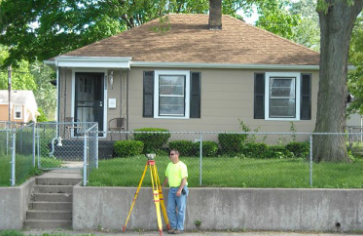
This initiative will produce detailed maps to hep Des Plaines River communities better understand their flood risk and plan effectively for future flooding. Structural flood damage assessments will be developed for all areas in the floodplain identified as at risk based on annual flooding probabilities. These assessments will include analyses at various flood depths and incorporate survey data, such as the lowest elevation water can enter a building and the first-floor elevation for residential, commercial, and industrial structures. Data sources will include parcel information, Geographic Information System (GIS) datasets, and elevation certificates provided by local counties and municipalities.

Project Benefits

  • As a result of this project, state, county, and local community officials will have access to enhanced flood risk information and tools to assist with community communication and decision-making regarding land-use and future development in high-risk flood areas.       
  • Information shared with river communities will be used to inform and educate citizens about flood risk.
  • Flood risk assessments like this, recently conducted in Illinois on the Upper Mississippi River and Illinois River have already yielded immediate life safety and resiliency benefits as well as improved planning for the future.
  • This project will add another complete component to the growing statewide risk assessment database being developed and used by the State of Illinois.

By providing detailed insights and practical tools, this project aims to empower communities along the Des Plaines River to take proactive measures for flood preparedness and safety.

Contact Us

U.S. Army Corps of Engineers Chicago District: 312-846-5514
Illinois Department of Natural Resources - Office of Water Resources: 

217-524-9133