Study Overview

Congress Authorizes Flood Risk Management Study for the Tittabawassee River Watershed, Midland Michigan 

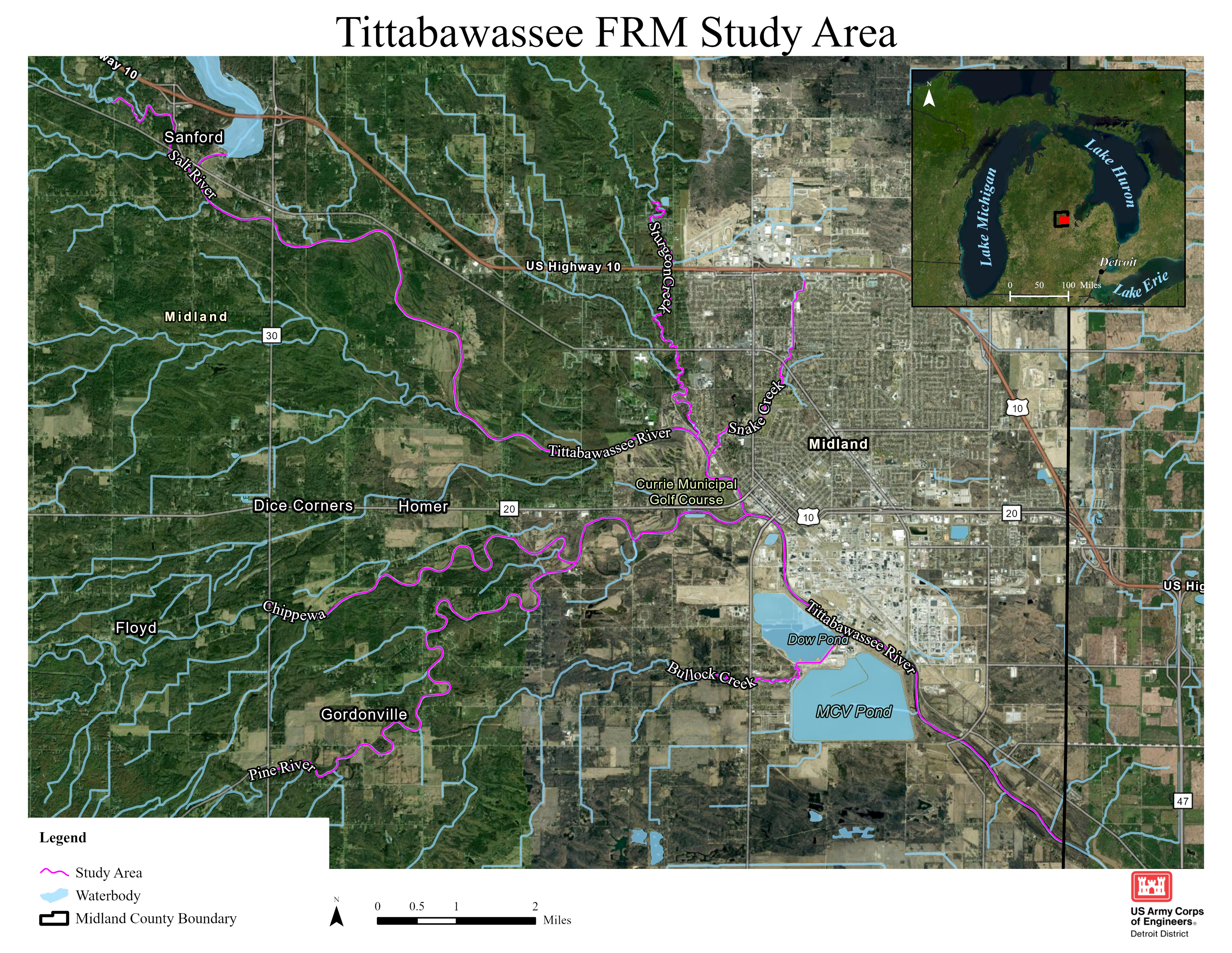
This study is authorized in the 2022 Water Resources Development Act (WRDA) which allows the U.S. Army Corps of Engineers (USACE) to initiate a flood risk management study to for the Tittabawassee River watershed in Midland County, Michigan. The project area for flood risk management and ecosystem restoration includes the Tittabawassee River, Chippewa River, Pine River, and Tobacco River.

USACE, Midland County, City of Midland, and Midland Business Alliance have executed a Feasibility Cost Sharing Agreement.

The study will investigate ways to mitigate for continual catastrophic flooding of the affected communities in the Tittabawassee River watershed including:

  • Riverine flooding.
  • Changes in land use and hydrology.
  • Ways to include ecosystem restoration measures.

The effects of changing weather patterns leading to more frequent flooding disaster declarations.

About the Study

The City of Midland has experienced significant flooding in 1986, 1996, 2013, 2017, and 2020. The Tittabawassee River in Midland has reached a moderate flood stage of 25-feet ten times and a major flood stage of 28-feet four times since 2010. This flooding causes damage to structures and infrastructure, impacts the local, regional, and national economy, and creates social hardship for Michiganders.

In June 2013, a frontal boundary stalled over Michigan dropping 3 to 6 inches of rain—resulting in a federal flooding disaster declaration. Severe storms and flooding in 2017 caused over $100M in damage to private and public property. Record precipitation in 2020 resulted in catastrophic failure of the privately owned Edenville and Sanford Dams that caused 10,000 residents to evacuate.

According to the Federal Emergency Management Agency (FEMA), there have been four disaster declarations in the study area since 2013. Explore FEMA’s Historical Flood Risk and Costs tool to better understand historical flood impact in your county.

After the May 2020 floods, the Midland Business Alliance worked with congressional representatives to authorize the study under the WRDA 2022 legislation. In 2024, USACE received an initial $500,000 to begin the study.

Our Shared Vision

To foster a shared vision for the Tittabawassee River Flood Risk Management Study, the USACE Detroit District, Midland Business Alliance, Midland County, and the City of Midland launched the study with a planning charrette that included local, regional, state, and federal government and NGO stakeholders in Midland from Nov. 19-21, 2024. The group developed a preliminary shared vision, which will continue to evolve as more stakeholders are engaged.

“This study will positively impact Midland County residents and the mid-Michigan region by identifying possible solutions to understand and reduce flood risk and reduce the severity and frequency of flood damages to the community and its most critical assets. The study will complement ongoing efforts of local and regional partners in building resilient flood risk infrastructure for a continued inclusive thriving community.”

The study area is the Tittabawassee River watershed in Midland County, including the Chippewa River, Pine River, and Tobacco River, downstream of Sanford Lake and Dam.

Scope, Schedule, and Budget

The key components of the study scope include a riverine flooding analysis, investigating impacts to live safety and public health, and management measures to reduce damages to structures and infrastructure. Deliverables will include a full array of alternatives and comprehensive benefit considerations, NEPA compliance, and community outreach.

The study duration is expected to be three-year and $3 million federal cost. Once a schedule and budget are approved by the Assistant Secretary for the Army of Civil Works, it will be posted. The bulk of the study time and funding will be allocated to the alternative evaluation and analysis phase. This phase will include developing 2D hydraulic and hydrologic modeling, creating various economic models, preliminary engineering and design of potential alternatives, and analyzing environmental, historical, and cultural resources as well as community considerations.

Plan Formulation

The Six-Step Planning Process

The USACE planning process is a structured approach to problem-solving. A six-step planning process is used iteratively, allowing steps to be repeated as needed for better problem understanding. Planning is performed by an interdisciplinary group of engineers, scientists, economists, and others. Stakeholder and public engagement play a major role, and public input in the decision-making process is valued.

Step 1: Identify Problems and Opportunities

The study team, in collaboration with local sponsor(s), tribal nations and the public, will verbalize and concur on the identified Problem(s) that need to be solved by the study and the recommended solutions. This seems simple, but different stakeholders sometimes have different opinions on what the specific water resources problems are in an area. This is a key first step in developing an effective array of alternatives or potential solutions, for managing flood risk in the region. Objectives are specific ‘goals’ of the project that will address the identified Problem(s). Opportunities are ‘improvements’ that could be made (beyond previous conditions), like habitat restoration, partnering opportunities or the addition of recreational features, while we are addressing the Problems.

Study's Draft Problems:

Problem 1: Repeated riverine flooding from the Tittabawassee River Watershed causes damage to critical public and private community infrastructure in the Midland region including health care, education, industry, commerce, agricultural, and essential services, resulting in personal and economic loss.

Problem 2: Frequent and recurring riverine flooding within the Tittabawassee River Watershed presents a danger to life safety, critical health care, and transportation routes, which are accessed in evacuations and by emergency services during the flood event.

Problem 3: Recurring riverine flood events mobilizes a significant amount of sediment that negatively impact the ecosystems within the Tittabawassee Watershed environment, water quality, wastewater treatment, and water supply for the City of Midland and surrounding county through erosion and increases fertilizer residue and other contaminates and pollution.


Study's Draft Objectives and Opportunities

Objectives​
  • Objective 1: Reduce the damages and impacts of riverine flooding on public and private property and infrastructure in Midland County over the 50-year period of analysis beginning in 2030​​
  • Objective 2: Decrease the risk to life safety and public health from flooding in the Tittabawassee River basin over the 50-year period of analysis beginning in 2030.
Opportunities
  • Maintain and enhance the native aquatic species within the basin, including potential improvements to existing fish passage projects.
  • Provide additional recreational opportunities that connect the surrounding communities to the environment.
  • Opportunity to improve water quality in the Tittabawassee River.
  • Opportunity to collaborate with a variety of partners to promote growth and tourism in the community.
  • Opportunity to promote recreational sites and greenspace along the river.
  • Opportunity to unite the region on the importance of watershed protection.
  • Opportunity to increase reliability of critical public infrastructure services that can be threatened during flooding events.
  • Opportunity to reduce the mental stress on local communities caused by flooding risk and the fear of flooding.
  • Opportunity to improve zoning in the area for sustainable growth.

Step 2: Inventorying and Forecasting Conditions

An inventory of key resources within the study area and a forecast of how these resources could change in the future is being developed. The study team is currently in the data gathering and scoping phase. If you have past studies, models, or other information you think may be useful, get in touch with us.

Step 3: Formulating Alternative Plans

The study team, in collaboration with local government, tribal nations, and the public, will identify an array of alternatives, or potential solutions, for managing flood risk in the region. When initial alternatives are identified, they will be added to an online map.  

Step 4: Evaluating Alternative Plans

The performance of and effects of alternative plans will be evaluated, both quantitively and qualitatively, by comparing without project and with project conditions. The study team will evaluate the comprehensive benefits of each alternative – economic, environmental, and social impacts will be considered.

Step 5: Comparing Alternative Plans

Comparing alternative plans will reveal the plan expected to produce the greatest net benefits (benefits – costs) from among the alternatives considered.

Step 6: Selecting a Plan

A recommended plan will be identified based on the results of steps 4 and 5. That plan will be described in the draft feasibility report that goes out for public and agency review. Eventually, the study will result in a feasibility report signed by the Chief of Engineers and sent to congress for additional project authorization and appropriation to implement the recommended plan.

Non-Federal Sponsors

Resources

Leave a Comment

*

*

Announcements

No announcements at this time.

Public Notices

No public notices at this time.